

surf: an exceptional spot. a little bit on oceans and meteorology iñaki garro, borja peñeñori
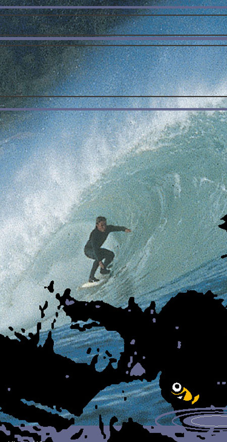
It’s a fine day and you find yourself coasting along the crest of a wave that has travelled 1,500 miles across the ocean and that, after three days, has finally found a bit of seabed which will actually cause it to break and, in the process, allow us all access to a wonderful spectacle in every sense of the word.
“ Someone blowing their arse off in Japan can really mess up a weather forecast”
Waves are a means for nature to transmit energy, but there is one small drawback to them; they are not a 100% predictable; you just have to be in the right place at the right time. That’s all there is to it. This is why we shall endeavour to explain how waves come about and how to read the weather map properly. It may not be the most scientific of methods but it’s almost always worked for us so far. We’re basically letting you in on this so that you’ll be able to draw your own conclusions, and so avoid having to rely on the weather forecasters who do not exactly have surfers in mind when telling the world what weather to expect. We’d just like to warn you that there are so many ways to interpret the weather chart that it’s seriously difficult to get it right. If we also take the theory of chaos into consideration, you know, the one that says somebody farting in Japan can foul up any forecast, then to pin down what the weather will be like in four days is a miracle.
Anecdotes on different phenomenon: the tsunami and the bore
You don’t really have to know how waves work to be able to tell whether to expect them in two days or not, but to know how, no matter how little, is a great buzz. It’s also full of curious anecdotes like the one about the tsunami that on the 27th of August in 1883 was set in motion by the explosion of the volcano to be found on the island of Krakatoa, in the Sunda Straits between Sumatra and Java. It set off three waves that measured between 20 and 40 metres in height. These waves reached speeds of over 500 km/h and travelled round the world killing 36,000 people in the process. A Dutch Cannon-ship that was in the area at the time was later found 8oo metres inland at a height of nine metres. Chains from the anchor of the same boat were found in the Chilean port of Valparaiso (there is no explanation of how this happened – it’s over 9,000 miles away!). This phenomenon was even felt in the Channel Tunnel where a considerable increase in sea-level was noted.
There’s also the case of the mascaret, aka a bore. This is a type of wave created in river mouths that can be formed due to several circumstances such as the lay of the seabed and the riverbed, strong sea currents and lively tides. In 1843, at the spot where the mouths of the Seine and the Ruan meet, an eight metre-tall wave was formed and it swept about 8o kilometres upriver causing extensive flooding and sinking every type of boat it met on its way. Victor Hugo’s daughter was aboard one of these boats celebrating her honeymoon. We haven’t come across any recollection of the incident in his writings.
Giant waves blown up by strong winds also reach spectacular heights. The highest on record was spotted on the 7th of February, 1933 in the North Pacific. It attained a height of 34 metres. An American Navy vessel, the USS Ramapo, had to ride it out. We’re pretty damn sure that the ship’s captain, R.P. Withemarsh, wasn’t exactly reaching out for his longboard as he gazed at the huge cracker from stern.
“The tide is waves that travel around the world.”
The surface of the sea never ceases to move. These movements are generally called waves. Waves are caused by different things: wind, seismic movement, land slides, meteorites, underwater volcanoes, gravitational influence of the moon and the sun (the tide is waves that travel round the world), water being churned up by high-speed boats,... The type of waves that surfers are really interested in are the more or-less predictable, manageable in size and periodical ones – waves that occur at regular intervals. Only waves produced by the wind meet all the requisites for surfing.
Several factors have to combine for the wind to produce waves:
- the wind has to have the necessary intensity (i.e. strength)
- this wind has to blow in the same direction over a considerable stretch of sea (this distance is called fetch)
- it has to blow long enough for waves to be able to form
When you look at a map of isobars, make sure these are long enough, close together and heading towards your spot without actually reaching the spot without changing direction, as this would produce on-shore wind ( frontal, really bad for surfing). To be sure of having ideal conditions the bars must change direction before it gets to your spot. The bars should approach your spot from land and head out to sea. This provokes land winds and these are ideal for surfing.
There are basically two types of waves that reach the coast: surges provoked by local winds that disappear as soon as the wind does, and deep sea waves which are formed in far off places in the ocean and die on the seashore (these are normally bigger). We’re more interested in the second type. We need to know the characteristics of the wind (fetch, duration and intensity) where the waves are formed in order to be able to predict their size by the time they reach the coast. We’ll be able to do this by reading isobar maps ( these are the lines we see on weather maps that detail different atmospheric pressures). The wind follows the direction of the isobars. They turn in a clockwise direction around anti-cyclones and anti-clockwise around storms ( this is in the northern hemisphere – in Argentina it’s the other way round). The proximity of the isobars to each other enables us to predict the strength; the closer the bars, the stronger the winds. The fetch is determined by the distance the isobars go in the same direction.
The speed of the wave depends on several factors, but in general, waves on the open-sea travel at about 30km/h.
“Energy is what moves at high sea, not water.”
What we have to take into account here is that according to the theory, it’s energy that moves at high sea, not water. There is no net transportation of water as a wave advances at high sea. The particles affected move vertically in a circular fashion. That is to say, they don’t really change position. This means that energy is moved, but not mass. We could say that waves house the wind energy produced in the North Atlantic, and that they are kind enough to bring it to the coast where you can change into kinetic energy with your surf board.
Things begin to change when the waves come into contact with the seabed. The brushing off of the seabed causes the waves to become steeper and higher. Finally, the wave reaches a critical stage where it can no longer sustain itself and the upper part travels more quickly than the lower part. This causes the surface of the sea to move. The wave breaks and now there’s water being transported as the energy stored within is unleashed in the movement of water, noise, costal erosion, sand movement... and, eventually, the movement of the surfer (or, as the case maybe, the surfer getting sent flying arse-ways).
The direction of the deep-sea is of the utmost importance when you want to find out about the quality of waves at each particular spot. The shape of the coastline also affects the direction a wave will take as it nears the shoreline. This is known as refraction. They really change direction when they hit the coast. Finally, after travelling 1,500 miles in three days, the energy stirred up on the marine surface to the North-West of Ireland ends up in unforgettable sessions on the Basque coast.
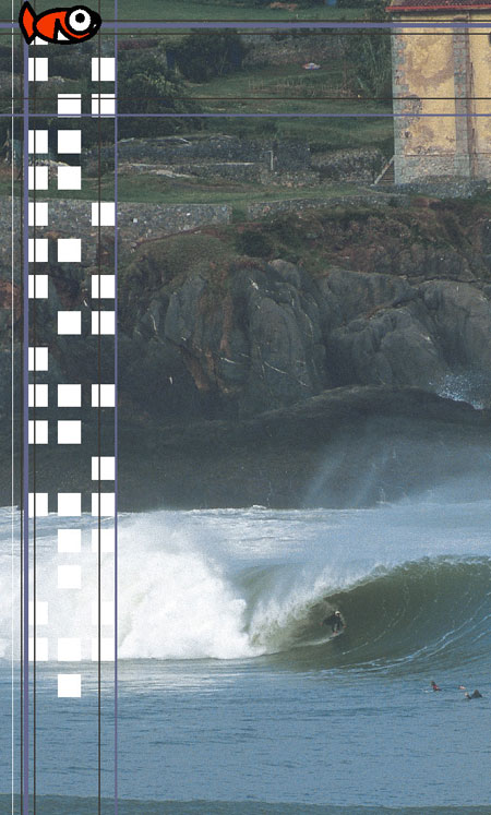
The special conditions found at the sand-bank in Mundaka, such as its orientation, its estuary and the lie of the bank itself ( although, being sand, it moves), make this one of the best places to surf in the world in Autumn.
“ Someone blowing their arse off in Japan can really mess up a weather forecast”
Waves are a means for nature to transmit energy, but there is one small drawback to them; they are not a 100% predictable; you just have to be in the right place at the right time. That’s all there is to it. This is why we shall endeavour to explain how waves come about and how to read the weather map properly. It may not be the most scientific of methods but it’s almost always worked for us so far. We’re basically letting you in on this so that you’ll be able to draw your own conclusions, and so avoid having to rely on the weather forecasters who do not exactly have surfers in mind when telling the world what weather to expect. We’d just like to warn you that there are so many ways to interpret the weather chart that it’s seriously difficult to get it right. If we also take the theory of chaos into consideration, you know, the one that says somebody farting in Japan can foul up any forecast, then to pin down what the weather will be like in four days is a miracle.
Anecdotes on different phenomenon: the tsunami and the bore
You don’t really have to know how waves work to be able to tell whether to expect them in two days or not, but to know how, no matter how little, is a great buzz. It’s also full of curious anecdotes like the one about the tsunami that on the 27th of August in 1883 was set in motion by the explosion of the volcano to be found on the island of Krakatoa, in the Sunda Straits between Sumatra and Java. It set off three waves that measured between 20 and 40 metres in height. These waves reached speeds of over 500 km/h and travelled round the world killing 36,000 people in the process. A Dutch Cannon-ship that was in the area at the time was later found 8oo metres inland at a height of nine metres. Chains from the anchor of the same boat were found in the Chilean port of Valparaiso (there is no explanation of how this happened – it’s over 9,000 miles away!). This phenomenon was even felt in the Channel Tunnel where a considerable increase in sea-level was noted.
There’s also the case of the mascaret, aka a bore. This is a type of wave created in river mouths that can be formed due to several circumstances such as the lay of the seabed and the riverbed, strong sea currents and lively tides. In 1843, at the spot where the mouths of the Seine and the Ruan meet, an eight metre-tall wave was formed and it swept about 8o kilometres upriver causing extensive flooding and sinking every type of boat it met on its way. Victor Hugo’s daughter was aboard one of these boats celebrating her honeymoon. We haven’t come across any recollection of the incident in his writings.
Giant waves blown up by strong winds also reach spectacular heights. The highest on record was spotted on the 7th of February, 1933 in the North Pacific. It attained a height of 34 metres. An American Navy vessel, the USS Ramapo, had to ride it out. We’re pretty damn sure that the ship’s captain, R.P. Withemarsh, wasn’t exactly reaching out for his longboard as he gazed at the huge cracker from stern.
“The tide is waves that travel around the world.”
The surface of the sea never ceases to move. These movements are generally called waves. Waves are caused by different things: wind, seismic movement, land slides, meteorites, underwater volcanoes, gravitational influence of the moon and the sun (the tide is waves that travel round the world), water being churned up by high-speed boats,... The type of waves that surfers are really interested in are the more or-less predictable, manageable in size and periodical ones – waves that occur at regular intervals. Only waves produced by the wind meet all the requisites for surfing.
Several factors have to combine for the wind to produce waves:
- the wind has to have the necessary intensity (i.e. strength)
- this wind has to blow in the same direction over a considerable stretch of sea (this distance is called fetch)
- it has to blow long enough for waves to be able to form
When you look at a map of isobars, make sure these are long enough, close together and heading towards your spot without actually reaching the spot without changing direction, as this would produce on-shore wind ( frontal, really bad for surfing). To be sure of having ideal conditions the bars must change direction before it gets to your spot. The bars should approach your spot from land and head out to sea. This provokes land winds and these are ideal for surfing.
There are basically two types of waves that reach the coast: surges provoked by local winds that disappear as soon as the wind does, and deep sea waves which are formed in far off places in the ocean and die on the seashore (these are normally bigger). We’re more interested in the second type. We need to know the characteristics of the wind (fetch, duration and intensity) where the waves are formed in order to be able to predict their size by the time they reach the coast. We’ll be able to do this by reading isobar maps ( these are the lines we see on weather maps that detail different atmospheric pressures). The wind follows the direction of the isobars. They turn in a clockwise direction around anti-cyclones and anti-clockwise around storms ( this is in the northern hemisphere – in Argentina it’s the other way round). The proximity of the isobars to each other enables us to predict the strength; the closer the bars, the stronger the winds. The fetch is determined by the distance the isobars go in the same direction.
The speed of the wave depends on several factors, but in general, waves on the open-sea travel at about 30km/h.
“Energy is what moves at high sea, not water.”
What we have to take into account here is that according to the theory, it’s energy that moves at high sea, not water. There is no net transportation of water as a wave advances at high sea. The particles affected move vertically in a circular fashion. That is to say, they don’t really change position. This means that energy is moved, but not mass. We could say that waves house the wind energy produced in the North Atlantic, and that they are kind enough to bring it to the coast where you can change into kinetic energy with your surf board.
Things begin to change when the waves come into contact with the seabed. The brushing off of the seabed causes the waves to become steeper and higher. Finally, the wave reaches a critical stage where it can no longer sustain itself and the upper part travels more quickly than the lower part. This causes the surface of the sea to move. The wave breaks and now there’s water being transported as the energy stored within is unleashed in the movement of water, noise, costal erosion, sand movement... and, eventually, the movement of the surfer (or, as the case maybe, the surfer getting sent flying arse-ways).
The direction of the deep-sea is of the utmost importance when you want to find out about the quality of waves at each particular spot. The shape of the coastline also affects the direction a wave will take as it nears the shoreline. This is known as refraction. They really change direction when they hit the coast. Finally, after travelling 1,500 miles in three days, the energy stirred up on the marine surface to the North-West of Ireland ends up in unforgettable sessions on the Basque coast.
The special conditions found at the sand-bank in Mundaka, such as its orientation, its estuary and the lie of the bank itself ( although, being sand, it moves), make this one of the best places to surf in the world in Autumn.